Scenery along China's Yunnan-Xizang Highway, 50 years after its opening
Source: Xinhua | 2026-07-07 | Editor:Evan
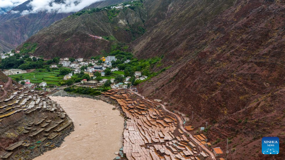
An aerial drone photo taken on July 1, 2026 shows salt fields alongside Lancang River in Mangkam County, Qamdo, southwest China's Xizang Autonomous Region. On July 6, 1976, the Yunnan-Xizang Highway, a vital trunk road in China's southwestern border regions, was fully completed and opened to traffic.
Stretching 715 kilometers from Xiaguan County in Yunnan Province to Mangkam County in Xizang Autonomous Region, the route crosses the Jinsha and Lancang rivers, traverses the rugged and geologically complex Hengduan Mountains, and climbs over snow-capped passes.
Over the past 50 years since it opened to traffic, the highway has undergone multiple upgrades and renovations. As motorists travel along its winding route, breathtaking scenery unfolds around every bend. (Xinhua/Hu Chao)
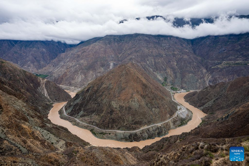
An aerial drone photo taken on July 1, 2026 shows a bend of the Jinsha River, the upper section of the Yangtze River, southwest China's Yunnan Province. On July 6, 1976, the Yunnan-Xizang Highway, a vital trunk road in China's southwestern border regions, was fully completed and opened to traffic.
Stretching 715 kilometers from Xiaguan County in Yunnan Province to Mangkam County in Xizang Autonomous Region, the route crosses the Jinsha and Lancang rivers, traverses the rugged and geologically complex Hengduan Mountains, and climbs over snow-capped passes.
Over the past 50 years since it opened to traffic, the highway has undergone multiple upgrades and renovations. As motorists travel along its winding route, breathtaking scenery unfolds around every bend. (Xinhua/Jiang Wenyao)

Tourists visit the ancient town of Dali, southwest China's Yunnan Province, April 14, 2024. On July 6, 1976, the Yunnan-Xizang Highway, a vital trunk road in China's southwestern border regions, was fully completed and opened to traffic.
Stretching 715 kilometers from Xiaguan County in Yunnan Province to Mangkam County in Xizang Autonomous Region, the route crosses the Jinsha and Lancang rivers, traverses the rugged and geologically complex Hengduan Mountains, and climbs over snow-capped passes.
Over the past 50 years since it opened to traffic, the highway has undergone multiple upgrades and renovations. As motorists travel along its winding route, breathtaking scenery unfolds around every bend. (Xinhua/Hu Chao)
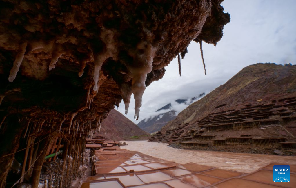
This photo taken on July 1, 2026 shows salt fields alongside Lancang River in Mangkam County, Qamdo, southwest China's Xizang Autonomous Region. On July 6, 1976, the Yunnan-Xizang Highway, a vital trunk road in China's southwestern border regions, was fully completed and opened to traffic.
Stretching 715 kilometers from Xiaguan County in Yunnan Province to Mangkam County in Xizang Autonomous Region, the route crosses the Jinsha and Lancang rivers, traverses the rugged and geologically complex Hengduan Mountains, and climbs over snow-capped passes.
Over the past 50 years since it opened to traffic, the highway has undergone multiple upgrades and renovations. As motorists travel along its winding route, breathtaking scenery unfolds around every bend. (Xinhua/Jiang Wenyao)

This photo taken on March 8, 2023 shows a view of the ancient town of Dukezong in Shangri-la, Deqen Tibetan Autonomous Prefecture, southwest China's Yunnan Province. On July 6, 1976, the Yunnan-Xizang Highway, a vital trunk road in China's southwestern border regions, was fully completed and opened to traffic.
Stretching 715 kilometers from Xiaguan County in Yunnan Province to Mangkam County in Xizang Autonomous Region, the route crosses the Jinsha and Lancang rivers, traverses the rugged and geologically complex Hengduan Mountains, and climbs over snow-capped passes.
Over the past 50 years since it opened to traffic, the highway has undergone multiple upgrades and renovations. As motorists travel along its winding route, breathtaking scenery unfolds around every bend. (Xinhua/Hu Chao)

An aerial drone photo taken on Nov. 8, 2024 shows a sunset view of the ancient city of Lijiang, southwest China's Yunnan Province. On July 6, 1976, the Yunnan-Xizang Highway, a vital trunk road in China's southwestern border regions, was fully completed and opened to traffic.
Stretching 715 kilometers from Xiaguan County in Yunnan Province to Mangkam County in Xizang Autonomous Region, the route crosses the Jinsha and Lancang rivers, traverses the rugged and geologically complex Hengduan Mountains, and climbs over snow-capped passes.
Over the past 50 years since it opened to traffic, the highway has undergone multiple upgrades and renovations. As motorists travel along its winding route, breathtaking scenery unfolds around every bend. (Xinhua/Hu Chao)

An aerial drone photo taken on Oct. 26, 2025 shows tourists watching a performance at the Yulong Snow Mountain scenic spot in Lijiang City, southwest China's Yunnan Province. On July 6, 1976, the Yunnan-Xizang Highway, a vital trunk road in China's southwestern border regions, was fully completed and opened to traffic.
Stretching 715 kilometers from Xiaguan County in Yunnan Province to Mangkam County in Xizang Autonomous Region, the route crosses the Jinsha and Lancang rivers, traverses the rugged and geologically complex Hengduan Mountains, and climbs over snow-capped passes.
Over the past 50 years since it opened to traffic, the highway has undergone multiple upgrades and renovations. As motorists travel along its winding route, breathtaking scenery unfolds around every bend. (Xinhua/Hu Chao)

An aerial drone photo taken on May 6, 2024 shows a view of Erhai Lake in Dali, southwest China's Yunnan Province. On July 6, 1976, the Yunnan-Xizang Highway, a vital trunk road in China's southwestern border regions, was fully completed and opened to traffic.
Stretching 715 kilometers from Xiaguan County in Yunnan Province to Mangkam County in Xizang Autonomous Region, the route crosses the Jinsha and Lancang rivers, traverses the rugged and geologically complex Hengduan Mountains, and climbs over snow-capped passes.
Over the past 50 years since it opened to traffic, the highway has undergone multiple upgrades and renovations. As motorists travel along its winding route, breathtaking scenery unfolds around every bend. (Xinhua/Hu Chao)

An aerial drone photo taken on July 2, 2026 shows a view of Meili Snow Mountain in Deqen Tibetan Autonomous Prefecture, southwest China's Yunnan Province. On July 6, 1976, the Yunnan-Xizang Highway, a vital trunk road in China's southwestern border regions, was fully completed and opened to traffic.
Stretching 715 kilometers from Xiaguan County in Yunnan Province to Mangkam County in Xizang Autonomous Region, the route crosses the Jinsha and Lancang rivers, traverses the rugged and geologically complex Hengduan Mountains, and climbs over snow-capped passes.
Over the past 50 years since it opened to traffic, the highway has undergone multiple upgrades and renovations. As motorists travel along its winding route, breathtaking scenery unfolds around every bend. (Xinhua/Hu Chao)

An aerial drone photo taken on July 2, 2026 shows a view of Meili Snow Mountain in Deqen Tibetan Autonomous Prefecture, southwest China's Yunnan Province. On July 6, 1976, the Yunnan-Xizang Highway, a vital trunk road in China's southwestern border regions, was fully completed and opened to traffic.
Stretching 715 kilometers from Xiaguan County in Yunnan Province to Mangkam County in Xizang Autonomous Region, the route crosses the Jinsha and Lancang rivers, traverses the rugged and geologically complex Hengduan Mountains, and climbs over snow-capped passes.
Over the past 50 years since it opened to traffic, the highway has undergone multiple upgrades and renovations. As motorists travel along its winding route, breathtaking scenery unfolds around every bend. (Xinhua/Hu Chao)

An aerial drone photo taken on July 1, 2026 shows salt fields alongside Lancang River in Mangkam County, Qamdo, southwest China's Xizang Autonomous Region. On July 6, 1976, the Yunnan-Xizang Highway, a vital trunk road in China's southwestern border regions, was fully completed and opened to traffic.
Stretching 715 kilometers from Xiaguan County in Yunnan Province to Mangkam County in Xizang Autonomous Region, the route crosses the Jinsha and Lancang rivers, traverses the rugged and geologically complex Hengduan Mountains, and climbs over snow-capped passes.
Over the past 50 years since it opened to traffic, the highway has undergone multiple upgrades and renovations. As motorists travel along its winding route, breathtaking scenery unfolds around every bend. (Xinhua/Hu Chao)

An undated aerial drone photo shows a view of the Three Pagodas at Chongsheng Temple in Dali, southwest China's Yunnan Province. On July 6, 1976, the Yunnan-Xizang Highway, a vital trunk road in China's southwestern border regions, was fully completed and opened to traffic.
Stretching 715 kilometers from Xiaguan County in Yunnan Province to Mangkam County in Xizang Autonomous Region, the route crosses the Jinsha and Lancang rivers, traverses the rugged and geologically complex Hengduan Mountains, and climbs over snow-capped passes.
Over the past 50 years since it opened to traffic, the highway has undergone multiple upgrades and renovations. As motorists travel along its winding route, breathtaking scenery unfolds around every bend. (Xinhua/Hu Chao)

This photo taken on July 2, 2026 shows a view of Meili Snow Mountain in Deqen Tibetan Autonomous Prefecture, southwest China's Yunnan Province. On July 6, 1976, the Yunnan-Xizang Highway, a vital trunk road in China's southwestern border regions, was fully completed and opened to traffic.
Stretching 715 kilometers from Xiaguan County in Yunnan Province to Mangkam County in Xizang Autonomous Region, the route crosses the Jinsha and Lancang rivers, traverses the rugged and geologically complex Hengduan Mountains, and climbs over snow-capped passes.
Over the past 50 years since it opened to traffic, the highway has undergone multiple upgrades and renovations. As motorists travel along its winding route, breathtaking scenery unfolds around every bend. (Xinhua/Jiang Wenyao)
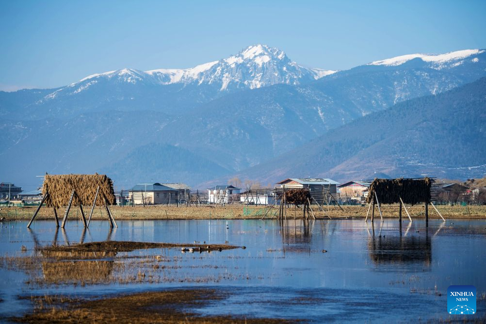
This photo taken on March 16, 2021 shows a view of the Napa Lake Nature Reserve in Shangri-la of Deqen Tibetan Autonomous Prefecture, southwest China's Yunnan Province. On July 6, 1976, the Yunnan-Xizang Highway, a vital trunk road in China's southwestern border regions, was fully completed and opened to traffic.
Stretching 715 kilometers from Xiaguan County in Yunnan Province to Mangkam County in Xizang Autonomous Region, the route crosses the Jinsha and Lancang rivers, traverses the rugged and geologically complex Hengduan Mountains, and climbs over snow-capped passes.
Over the past 50 years since it opened to traffic, the highway has undergone multiple upgrades and renovations. As motorists travel along its winding route, breathtaking scenery unfolds around every bend. (Xinhua/Hu Chao)

An aerial drone photo taken on Nov. 11, 2024 shows a view of Yulong Snow Mountain from a park in Lijiang City, southwest China's Yunnan Province. On July 6, 1976, the Yunnan-Xizang Highway, a vital trunk road in China's southwestern border regions, was fully completed and opened to traffic.
Stretching 715 kilometers from Xiaguan County in Yunnan Province to Mangkam County in Xizang Autonomous Region, the route crosses the Jinsha and Lancang rivers, traverses the rugged and geologically complex Hengduan Mountains, and climbs over snow-capped passes.
Over the past 50 years since it opened to traffic, the highway has undergone multiple upgrades and renovations. As motorists travel along its winding route, breathtaking scenery unfolds around every bend. (Xinhua/Hu Chao)

An aerial drone photo taken on Nov. 24, 2025 shows a view of Xizhou Ancient Town of Dali Bai Autonomous Prefecture, southwest China's Yunnan Province. On July 6, 1976, the Yunnan-Xizang Highway, a vital trunk road in China's southwestern border regions, was fully completed and opened to traffic.
Stretching 715 kilometers from Xiaguan County in Yunnan Province to Mangkam County in Xizang Autonomous Region, the route crosses the Jinsha and Lancang rivers, traverses the rugged and geologically complex Hengduan Mountains, and climbs over snow-capped passes.
Over the past 50 years since it opened to traffic, the highway has undergone multiple upgrades and renovations. As motorists travel along its winding route, breathtaking scenery unfolds around every bend. (Xinhua/Hu Chao)

An aerial drone photo taken on Nov. 9, 2024 shows a view of the Lanyue (Blue Moon) Valley in Lijiang City, southwest China's Yunnan Province. On July 6, 1976, the Yunnan-Xizang Highway, a vital trunk road in China's southwestern border regions, was fully completed and opened to traffic.
Stretching 715 kilometers from Xiaguan County in Yunnan Province to Mangkam County in Xizang Autonomous Region, the route crosses the Jinsha and Lancang rivers, traverses the rugged and geologically complex Hengduan Mountains, and climbs over snow-capped passes.
Over the past 50 years since it opened to traffic, the highway has undergone multiple upgrades and renovations. As motorists travel along its winding route, breathtaking scenery unfolds around every bend. (Xinhua/Hu Chao)
You May Like
-
Baisha ancient town in China's Yunnan injects new vitality i...
In recent years, Baisha ancient town has drawn on its historical legacy and rich ethnic cultural resources to advance the preservation, transmission and innovat...
InKunming 2026-06-22 -
A Letter from Kunming | Kunming, China Invites Global Busine...
Open and sincere, Kunming welcomes the world; in its summer months, gentle breezes are a constant companion.
InKunming 2026-06-10 -
Cycling Along Dianchi Lake: A Date with the Sunset
As the Dianchi Lake Greenway gradually becomes fully connected, its uninterrupted lake views, long green corridor, and spectacular sunsets have made the surrou...
InKunming 2026-06-10 -
Chinese vice premier urges deepened efforts for high-quality...
Chinese Vice Premier Ding Xuexiang called for deepened efforts to advance the high-quality development of basic education during a recent inspection tour in s...
InKunming 2026-06-04 -
View of Erhai Lake in China's Yunnan
The view of Erhai Lake in Dali, southwest China's Yunnan Province.
InKunming 2026-06-02 -
China-France Young Leaders Program opens in Yunnan to boost ...
Officials, experts, and business leaders from China and France gathered in Kunming, Yunnan province, on Friday to promote technology and innovation collaboratio...
InKunming 2026-06-02 -
Living by the waters, walking along Dianchi — romance and d...
What defines Kunming? A national historic and cultural city with a distinctive plateau lakeside character, Kunming is naturally endowed with beauty, uniqueness ...
InKunming 2026-06-01 -
Forum on promoting global ecological civilization held in so...
A forum focused on advancing global ecological civilization was held on Saturday in Dali.
InKunming 2026-06-01 -
Friendship gallops across the Kazakh steppe
InKunming 2026-05-28 -
Feature: From poverty trap to model village: One scholar's 1...
Professor Li Xiaoyun's first steps into the Yao ethnic village of Hebian, literally translated as "riverside" at the end of 2014, felt less like a research tr...
InKunming 2026-05-27